Schedule of Workshops and Topics to be Covered
Unless otherwise specified, all will be online over Zoom and will run on Fridays from 5:00 – 6:30pm. Below is the approximate schedule of topics from this Fall that will be updated to reflect the Spring semester academic calendar.
Selected Projects
Renewable Energy #10: Kaylee, Eric, Flor, Maka,
Waste Quantifying #9: Mariam, Emran, and Shivangini
Heat Waves Urban Heat Island #8: Leah and Fatima
OEM HMP #1: Julio, Genesis
Bird Safe Glass #3: Ariandy, Rebecca, and Mohamed
- Weekly, Fridays 5PM-6:30PM (likely ending by 6:15PM)
- All meetings will be online. Mid Year Presentations will be in person.
- Friday, February 3rd (students and faculty)
- Individual introductions (pecha kucha style): each student/mentor please say your name/pronouns, academic background, capstone project, what you hope to get out of the project, what you see as a potential challenge to meeting your project goals, and one item from the readings you found uniquely compelling.
- A review of the syllabus and expectations for mentors as well as students
- Minimum 25 pages in final paper per group member (not including appendices/ bibliographies)
- Group members may receive different grades
- Must produce new deliverables that build on a literature review of existing research (examples of what is and what is not enough)
- Review of drafted, optional grading rubric for mentors
- Review of CUNY academic integrity policy
- Mid Year: Presentation and early draft.
- Save the Date: Friday May 12th for Mid Year Presentations (late afternoon/early evening).
Finally each student will workshop a personal writing sample (no more than one page) from another class with another student selected at random.
- February 10th
- Back to Basics! Background research/literature review and healthy citation management
- The benefits of diagramming your research project
- Assignment #1: Diagram your project for next workshop as a group and be ready to discuss it (see site resources for various software you might want to use)
- Project Management Logs
- Description of Assignment #2: A group PML entry (due the following Wednesday)
- February 17th
- Diagram discussions from each group and conversation
- Back to Basics! What makes a good paper?
- Description of Annotated Bibliographies
- Description of Assignment #3: 3 Annotated Unique Bibliography Entries from Each Group Member (due the following Wednesday)
- February 24th
- Discussion of annotations from each student in breakout groups as teams
- Back to Basics! What makes a good presentation?
- Description of Assignment #4: For next class, each student should prepare a 5 minute, scripted lightning talk (with slides) on one of the key resources for their background research/literature review. Students should be prepared to give feedback on presentations next class.
- March 3rd
- Lightning talks and feedback
- March 10th
- Lightning talks and feedback
- Description of expectations for mid-year written report and for mid-year presentations
- Students should bring a personal writing sample (no more than 1 page) next week to workshop to discuss in small groups of ~3.
- March 17th
- Any remaining lightning talks and feedback
- Final paper formatting discussion
- March 24th
- Back to Basics! Research methods
- Description of Assignment #5: For next class, each group should be prepared to discuss what research methods their project might use and why. Students should be prepared to give feedback.
- Small group writing workshop.
- March 31st
- Research methods discussion from each team and IRB discussion
- Description of Assignment #6: Mid-Year Presentation Drafts. Each group should prepare a maximum of a half hour talk on their work so far (each group member should speak) and we will have one or two talks per week. This is considered a longer “rough draft” of the mid year presentation.
- April 7th: Spring Recess (no workshop)
- April 14th: End of Spring Recess (no workshop)
- April 21st
- Final writing workshop: teams swap early section of papers
- April 28th (faculty advisors welcome)
- Midyear draft presentations
- May 5th (faculty advisors welcome)
- Midyear draft presentations
Friday May 12th: Mid-Year Presentations (4PM, the “Reading Day”) in SSA 107.
20 minute maximum concise presentation from each group, 20 minutes of feedback and discussion.
Projects on Offer For Spring 2023
1. NYC Hazard Mitigation Planning
Led by NYC OEM and Katherine
Objective
CUNY Project Proposal
Evaluate community risk and vulnerability of Brooklyn & Queens neighborhoods to increasingly severe weather events as a result of climate change to create a neighborhood-specific Hazard Mitigation Plan.
Background
NYC is often referred to as a City of Neighborhoods. Hundreds of neighborhoods exist within 59 Community Districts, ranging in size from less than 900 acres to almost 15,000 acres, and ranging in population from fewer than 35,000 residents to more than 200,000. Risk to natural hazards like extreme heat, flash flooding, and coastal flooding vary across these neighborhoods, creating the need for tailored, community-driven hazard mitigation plans to help NYC residents best prepare and recover for future weather events.
New York City Emergency Management (NYCEM) is in the process of updating its 2024 Hazard Mitigation Plan, the city’s web-based FEMA-mandated plan for assessing hazards that pose a risk to its people and infrastructure, and strategies for reducing the impacts of emergency events. NYCEM is looking to better engage our numerous communities in the planning process by partnering with academic institutions to create hyperlocal hazard mitigation planning projects that match the specific needs of each selected community.
The focus areas of this project will be inland areas of Brooklyn and Queens that were heavily impacted flash flooding during 2019 Post-Tropical Cyclone (PTC) Ida, which came with little warning and late in the evening. This resulted in 13 deaths –particularly in homes with basement units –and over $781 million in damages across the city.
Working closely with NYCEM and local community organizations, students will have the opportunity to apply urban planning skills and analysis to a multidisciplinary effort to combat the ever-growing threat of severe weather to historically underserved communities and play an integral role in creating a safer, better-prepared city.
Suggested Approaches
– Empower and support local community organizations to create neighborhood hazard mitigation plans that address urban planning challenges as they relate to hazardous events, climate change, and environmental justice
– Utilize existing preparedness and mitigation tools and resources in combination with planning skill and knowledge to support the development of a local hazard mitigation plan
– Document the planning process via a planning guide that details challenges, successes, and personalization added while developing the hazard mitigation plan
2. Energy Use and Carbon Emissions in the United States Residential Building Sector
Led by Professor Ben Leer (Architecture)
Objective: To calculate and compare the overall energy use of several realized residential building projects across the United States.
Background: The building sector accounts for almost 40% of the total energy consumed in the US (2021 EIA). Of this total about 21% is consumed by the residential sector. This total reflects the “operational energy” use of the buildings, and it does not account for the energy used to construct the building nor the amount of “embodied energy” used to extract, produce, and deliver building materials to site. For reference, the production of cement alone accounts for 8% of the total global CO2 emissions (IEA 2020). The combination of operational and embodied energy in the residential building sector makes it one of the largest contributors to global CO2 emissions.
In the hopes of combating this trend, many designers and builders are trying implement better building practices to reduce both operational and embodied carbon emissions. One of the most successful building practices to reduce energy use is the Passive House Standard. The Passive House Standard is an international building certification that relies on building science and state of the art energy modeling to reduce a building’s energy consumption by up to 75%.
This project aims to study several real-word Passive House projects across the United States. The team will analyze buildings across different climate zones comparing the energy use of each building against the current energy code. They will then study the embodied carbon associated with the materials used in construction, comparing different material choices. The final results will be a review of overall energy use for the different scenarios, both in material choice and performance targets.
Suggested Approach:
- Research energy use and emissions in the building sector. Including latest trends in energy modeling and embodied carbon calculations.
- Review the current residential building energy code as it compares to the Passive House Standard.
- Identify key projects from across different climate zones in the US.
- Use the Passive House Energy modeling software to calculate the operational energy use of each building.
- Model each building in reference to the residential energy code and compare it to the energy use of the PH standard.
- Calculate the embodied energy associated with modeled building system
- Compare different building materials and their effect on carbon emissions
- Present the findings of each building, material type and energy use compared to code
3. Bird-friendly? A study of architectural Glass on avian life in the urban environment
Led by Katherine Gloede Silverman
Note: This is a self formed project with full team–Rebecca and Ariandy.
Objective: Based on the analysis of the standards of Glass in modern architecture in New york city, a comparison of bird-friendly and non-bird-friendly glass properties and manufacturers and their effectiveness or non-effectiveness by the number of bird strikes on said buildings.
Background: Glass is an architectural innovation often used as transparent glazing on the envelope of a building used as an architectural feature that is seen on many buildings around the world and within the city of New York. Over the years, Glass in Architectural spaces has evolved to have properties that meet the demands of the people who occupy the buildings. From Glass that provides insulation to low emissivity. Glass has become part of the urban fabric in every city worldwide.
This project aims to study the window properties of bird-friendly Glass and make the information more accessible to architects, engineers, biologists, and manufacturers. The goal is to assess whether the bird-friendly Glass is as effective as companies’ or other organizations’ advertisements. Does it lower or eliminate the rate of birds hitting windows?
Over 1 Billion birds die annually when they strike or collide with a window. This is because the window appears invisible to them, birds flying right into it. Most of the birds that collide into windows will die from the impact of hitting the window as birds’ bodies are extremely fragile. Sometimes the birds are stunned when they smash into windows and fly away. The problem is that later on, this bird will most likely also die as they commonly have internal bleeding or bruising, especially in the brain, as they often collide with the window head first. Not all strikes happen for the same reason, but they can all be equally deadly.
There are three different types of collisions when birds hit windows. These collisions can be categorized as either daytime, nighttime, or territorial, and they happen for various reasons. Daytime and nighttime are the more common types of strikes over territorial. The reason for daytime collisions is that they see the reflection of plants in the window and think they can land on those plants, while lighted windows cause nighttime collisions. It is unknown why artificial light throws off normal migration patterns, but this confusion can make birds more prone to hitting windows at night. If they do not collide with the window at night, they might roost nearby and strike against it the next day. The last type of strike, territorial, is more common in the spring. Territorial strikes happen when birds see their reflection and think it is a rival bird, leading to them attacking the window in defense and therefore hitting it.
The two most common NYC birds that strike Glass are White-Throated sparrows and common yellowthroats. The following most common birds are Ovenbirds, black and white warblers, hermit thrushes, American redstarts, and northern parulas. These might be the most common species to hit the Glass, but they are far from the only resident or migratory birds that are unfortunate enough to collide with it. The end goal of this project is the comparison and study of bird-friendly Glass and its effects on the urban environment.
Bird-friendly glass approaches:
1. Fritting
2. Silk Screening
3. Ultraviolet Coating (Birds can see in Ultraviolet and humans cannot)
4. Pattern creation following a 2″ x4″ “mesh” design that is two inches horizontally and four inches vertically, as birds do not fly into spaces that are smaller than this size
Suggested Approaches
i.Literature review to assess what types of bird-friendly Glass are already in use and to understand how it is made and implemented into the building.
ii. Research the buildings around NYC that currently implement bird-friendly Glass into their design and choose facilities that use different types of methodology, along with a structure that does not use bird-friendly Glass as a control. Pick buildings near each other to lessen the odds of confounding variables.
iii. Create a walking route around buildings that will be walking in the same order/same way to maintain consistency. This will be done around dawn or just after sunrise to look for birds on the ground, as that is when strikes are most likely to happen. Resident birds could potentially strike Glass year-round. Higher rates of strikes are estimated around spring and fall as those are the migration times, meaning the volume of birds in the area is more elevated.
iv. Log times, building location, side of the building, bird species, weather conditions, and temperature into the datasheet. Living birds will be put into a paper bag and transported to Wild Bird Fund for Rehab.
v. at the end of the study, data will be compiled and assessed to see if certain areas had more strikes than others and evaluate reasons why this might be the case
vi. Make recommendations for the future on what we think the best practice is going forward.
Pre-requisites/Ideal Team
A student with a background in architecture can understand how Glass is manufactured and different building methods.
A student with a background in ecology and avian conservation must be able to identify birds found in the area and know basic facts about birds, such as behavior, habitat preference, and migration patterns.
4. Cultivating Urban Wild for Urban Food
Led by Zihao Zhang, Ph.D. Assistant Professor in Landscape Architecture
Objective
This student project will contribute to an ongoing research project based in the Spitzer School of Architecture that explores innovative robotic systems to produce food in urban ecosystems. Students will study the NYC food system and analyze the resources and opportunities to develop innovative models for urban agricultural practices in “leftover” spaces during urbanization. Students will design urban agricultural prototypes that can be replicated across NYC and other cities.
Background
The COVID-19 pandemic, the resultant supply-chain breakdown, and climate change have exacerbated the dysfunction of current urban food systems and exposed serious, complex food insecurity in US cities. Burgeoning community food gardens could both enhance urban food security and increase urban biodiversity to combat climate change. Urban community gardens, however, are often hands-on, grassroots “guerrilla gardens” maintained by individuals’ intense manual labor. Meanwhile, technological innovations target yield-driven, profit-driven large farms, and typically overlook small-scale, urban food gardens. Thus, urban communities lack adequate infrastructure and technology to sustain substantial agriculture that could potentially provide an alternative and sustainable food source. This research will design and pilot a climate-sensitive, innovative, urban food garden that synergistically integrates technology within urban ecosystems.
Suggested Approaches
- Study the urban food system from food production to distribution and consumption. Produce mappings to understand and illustrate these complex systems.
- Analyze geospatial information and evaluate potential sites for new types of urban agriculture. Develop site catalogs to categorize these potential sites.
- Design new urban agriculture prototypes that can leverage public resources and emerging technologies to engage a broader community to participate in urban agriculture.
Pre-requisities/Ideal Team
The ideal team would be comprised of team members of mixed backgrounds: someone with architecture, landscape architecture, urban design, or industrial design background; someone with a background in planning and policy; someone with a computer science or engineering background (or has coding experience). Students with experience in gardening, farming, and urban agriculture are most ideal.
5. Understanding and Predicting Dzud Events and Their Impacts in Middle and High Latitude Drylands
Mentor: Prof. Kyle McDonald, Department of Earth and Atmospheric Sciences
Objective:
Students will characterize dzud event risk and severity, assessing relationships between remote sensing
datasets (e.g. soil moisture, vegetation stress, landscape freeze/thaw state), dzud events, and associated socioeconomic impacts. Based on this analysis, students will develop an assessment framework for use in risk mitigation strategies. The understanding gained supports integration of physical and social sciences into decision making for anticipatory action.
Background:
Drylands in the middle and high latitudes have harsh environments with characteristically cold and arid
climates. The livelihoods of the people inhabiting these areas are threatened by constant climate-related natural hazards. Dzud is the Mongolian term for a natural disaster resulting from harsh winter conditions that reduce availability or accessibility of pastures, leading to an extensive loss of livestock/wildlife from either starvation or cold during the winter-spring. These events occur in grasslands and tundra in significant portions of the mid to high latitudes, covering approximately 45% of Earth’s terrestrial area. In Central Asia, these events have significant humanitarian impacts because they affect local livestock populations, especially in Mongolia where approximately 30% of the workforce is dependent on herding for a substantial part of their livelihoods. In North America, these events are called winter kill, and they can result in massive die-offs of wildlife.
The current dzud early warning system in Mongolia has been in place since 2015 and is developed by the Information and Research Institute of Meteorology, Hydrology and Environment (Mongolia) in collaboration with Nagoya University in Japan. However, fully characterizing summer and winter conditions associated with dzud risk has been a challenge, and false positives associated with prediction of dzud events are high.
This capstone study seeks to employ state-of-the-art remote sensing datasets collected from Earth orbit to develop risk and severity assessments for dzud events and associated socioeconomic impacts to inhabitants of dzud-prone regions. Initial emphasis will be on the dryland steppe of Mongolia where records of dzud events are available. Extension to other parts of the terrestrial high latitudes will include analysis of die-off events in North America.
Suggested Approaches:
- (i) Investigate the relationship between dzud event occurrence, non-frozen season soil moisture (SM)conditions, vegetation water stress, and winter/autumn/spring freeze/thaw (FT) state conditions using remote sensing datasets, ground-based station data, and dzud occurrence data. NASA’s Soil Moisture Active-Passive (SMAP) mission provides SM and land surface FT state datasets beginning in 2015. NASA’s ECOSTRESS mission provides vegetation water stress and precision thermal data characterizing surface temperature for approximately the last three years. Explore the role of FT timing and past summer SM for different vegetation zones in Mongolia.
- (ii) Produce remote sensing-informed dzud risk maps based on prior summer soil moisture, current freeze/thaw state conditions, and ancillary datasets through an analysis conducted in a GIS framework supporting multi-criteria decision analysis.
- (iii) Extend results to the regions of the global middle and high latitudes.
- (iv) Conduct risk and socioeconomic impact assessments.
Students should be comfortable working with computer analysis tools and a GIS analysis framework.
This project will be carried out in collaboration with scientists from the Carbon Cycle and Ecosystems group in the Division of Science at the NASA Jet Propulsion Laboratory, California Institute of Technology, Pasadena, California.
Figure 1: Examples of the impact of a dzud event on livestock in Mongolia. These events can often claim millions of livestock a year, affecting people’s livelihoods in significant ways. (Photo Credits: Left: UNDP Mongolia / Flickr, Right: Gerry Shih, thestar.com)
6. Reducing human health risk and exposure to wastewater spills in urban coastal environments
Faculty Mentor: Prof. Kyle McDonald, Department of Earth and Atmospheric Sciences
Objective:
The capstone team will employ remote sensing datasets from Earth-orbiting satellites to improve the understanding of Tijuana River discharge on water quality and associated health impacts in San Diego County, California. This project integrates aspects of remote sensing technology, public health and environmental justice.
Background:
The San Diego County Board of Supervisors recently declared that “pollution from the Tijuana River Valley [is] a public health crisis,” having led to 295 and 160 days of beach closures in Border Field State Park and Imperial Beach, CA, in 2020. In a 2017 case study, it was estimated that nearly 4% of 864,000 swimmers at San Diego beaches were sickened by a south-swell driven plume event containing massive amounts of untreated wastewater (Feddersen, et al., 2021). San Diego County’s Department of Environmental Health and Quality (DEHQ) works to protect beachgoers while preventing unnecessary closures that could negatively affect their beach tourism economy. This project will explore ways in which remote sensing can be used to improve understanding of Tijuana River plumes and enhance this decision process of DEHQ to protectpublichealth. Further,thisprojectaddressobjectivesofdiversity,equityinclusionandaccessibility (DEIA). The coastal zone is considered a common-pool resource and access is becoming increasingly limited due to climate change (i.e., sea level rise, extreme weather), growing population densities, and other factors. This project will help improve access by helping reduce the number of beach closures and by protecting environmental and public health.
Suggested Approaches:
- Develop and validate Tijuana River plume product suite using optical (Landsat-8, Sentinel-2, Planet, DESIS); thermal (Landsat-8, ECOSTRESS), and synthetic aperture radar (SAR) datasets (Sentinel-1).
- Evaluate plume product relative to DEHQ Bay and Beach program decisions using previously collect in situ measurements of wastewater contaminants.
- Evaluate impacts on urban coast access and equity issues in a policy brief.
This project will be carried out in collaboration with scientists from the Earth Science section in the Division of Science at the NASA Jet Propulsion Laboratory, California Institute of Technology, Pasadena, California.
Students should be comfortable working with computer analysis tools and a GIS analysis framework.
References:
Feddersen, F., Boehm, A. B., Giddings, S. N., Wu, X., & Liden, D. (2021). Modeling untreated wastewater evolution and swimmer illness for four wastewater infrastructure scenarios in
the San Diego-Tijuana (US/MX) border region. GeoHealth, 5, e2021GH000490. https://doi.org/10.1029/2021GH000490
7. Wildfire Impacts on Coastal Water Quality Collaborative
Faculty Mentor: Prof. Kyle McDonald, Department of Earth and Atmospheric Sciences
Objective:
The capstone team will assess impacts of the increasing prevalence of wildfire on coastal water quality and examine the intersection of associated wildfire impacts and stakeholder needs in California. This effort supports integration of remote seeing technologies, coast process science and social sciences related to climate change.
Background:
Wildfires in the western United States are expected to increase in frequency and intensity under a changing climate. There is an urgent need to quantify and anticipate wildfire impacts on aquatic ecosystems through changing watershed hydrology and nutrient transport, with coastal ecosystem response being particularly not well understood. This limited understanding of post-fire impacts on coastal water quality and infrastructure have resulted in challenges in local agency response and management. This project will help identify and explore post-fire monitoring protocols through the lens of space and airborne remote sensing, with the goal of improving understanding of watershed scale changes due to fire impacts after an event as well as supporting coordination efforts for monitoring post fire conditions and hazards.
Suggested Approaches:
- Develop and document understanding of stakeholder monitoring needs for post wildfire conditions and coastal impacts, in terms of datasets and technical capabilities.
- Review remote sensing assets that can complement and resolve coastal processes impacted by fires and develop exemplar case studies to show case capabilities.
- Report on opportunities at the intersection of remote sensing and post wildfire coastal monitoring and assessments in California.
Students should be comfortable working with computer analysis tools and a GIS analysis framework.
This project will be carried out in collaboration with scientists from the Earth Science section in the Division of Science at the NASA Jet Propulsion Laboratory, California Institute of Technology, Pasadena, California.
8. Assessment of Urban Heat Mitigation Strategies with Precision Remote Sensing of Thermal Signatures in New York City
Co-Mentors: Prof. Kyle McDonald, Department of Earth and Atmospheric Sciences Prof. Nicholas Steiner, Department of Earth and Atmospheric Sciences
Objective:
This project will assess the effectiveness of heat mitigation provided by the forests, woodlands and greenspace around NYC, and of heat mitigation strategies such as street-tree planting and installation of cool roofs. The team will use precision thermal infrared remote sensing datasets from NASA’s ECOSTRESS sensor, a thermal imaging instrument flown on the International Space Station (ISS) to assess effectiveness of strategies employed to mitigate urban heat in New York City.
Background:
Urban regions in and around New York City (NYC) experience urban heat island (UHI) with impacts that are exacerbated by climate change and heat wave events – phenomena that are increasing in frequency and intensity. Urban heat waves are a leading cause of global weather- related fatalities, and associated heat-related illnesses constitute a leading health problem for NYC and nationally. As urban vegetation is the most important factor in regulation of UHI, urban forest ecosystems can mitigate the negative impacts to health and energy usage from UHI. Furthermore, New York City has benefited from several strategies associated with climate change mitigation, and among these are NYC CoolRoofs and NYC Department of Parks & Recreation’s MillionTreesNYC.
NASA’s ECOsystem Spaceborne Thermal Radiometer Experiment on Space Station (ECOSTRESS) is providing precision thermal images of Earth’s terrestrial environments. Primarily intended to examine water use and water stress in plants, datasets from the ECOSTRESS thermal imaging sensor are also proving invaluable in assessing the thermal environment in urban settings. For example, assessments of ECOSTRESS thermal images over Los Angeles, California have demonstrated substantial reduction in neighborhood heating as a result of installation of CoolSeal paint on street surfaces (see Figure 1). As New York City is identified as a priority target for acquisition of ECOSTRESS data for urban regions worldwide, specialized ECOSTRESS products being derived to examine the NYC thermal environment.
The goal of this capstone project is to assess UHI mitigation associated with urban forests and the effectiveness of UHI mitigation strategies such as planting of street-trees and use of cool roof technologies. The Team will employ ECOSTRESS datasets in these assessments.
Suggested Approaches:
1) Assemble salient ECOSTRESS data into a data base focused on NYC and vicinity to support multi-year times series (2018- present) thermal environment assessment.
- 2) Assist project mentors with deployment and maintenance of monitoring stations that characterize meteorology and biophysical processes in trees. Stations will be deployed in several urban forests in and around NYC. Employ data collections to assess water use and water stress in trees as related to, e.g., heat stress and heat waves.
- 3) Examine time series ECOSTRESS thermal signatures at the local, neighborhood, and city scale, and coordinated with timing of installation of white and green roofs, and with street planting. Examine urban forest response to heat stress and heat waves observed with ECOSTRESS.
- 4) Assess changes in the spatio-temporal thermal signature across scales associated with mitigation strategies and urban forests.
- 5) Examine these results in the context of addressing environmental justice concerns in NYC.
Students should be comfortable working with computer analysis tools and a GIS analysis framework.
This project will be carried out in collaboration New York City Parks, the New York City Mayor’s Office of Environmental and Climate Justice, and with scientists from the Earth Science Section in the Division of Science at the NASA Jet Propulsion Laboratory, California Institute of Technology, Pasadena, California.
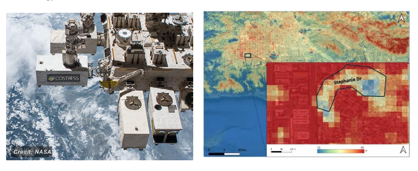
Figure 1. Left: ECOSTRESS is flown on the Japanese Experiment Module on International Space Station (https://ecostress.jpl.nasa.gov/mission). Right: ECOSTRESS thermal image showing the Los Angeles, California surface temperature at 70 meter resolution. The inset shows an exploded view of a neighbor where the roadway has been coated with CoolSeal paint. The reduction in the neighborhood temperature associated with application of this street coating is clearly observed in the ECOSTRESS thermal image. The primary goal of this capstone project is to assess similar heat mitigation in NYC associated with urban forests and with cool roof technologies and planning of street trees.
9. Quantifying reuse in New York City
Led by Professor Snehesh Ail (Engineering)
a. What is reuse and how does it stand in the waste management hierarchy
b. Why reuse? – quantify in terms of emission factors, landfill emissions, and how it supports NYC’s zero waste plan
c. What are the global reuse initiatives
d. How can you quantify reuse? – introduction to reuse impact calculator, developed here at the City College of New York, and used extensively by the Department of Sanitation New York (DSNY)
e. Project output:
i. Net emissions saved by reuse, compared to other waste management strategies.
ii. Material resource management, with respect to circular economy
iii. Analyzing health impact by adopting reuse waste management strategy
iv. Economics involved in implementing reuse waste management strategy in NYC – operation costs, reach out costs, innovative program costs
v. Answer a fundamental question: Would reuse impact other waste management operations such as, recycling, composting and waste-to-energy?
The students can reach out to organizations that engage in waste management strategies in NYC. Earth Engineering Center|CCNY can give out its web scraper algorithm for students to extract data from web-reuse activities.
Several major cities in the world are working towards zero-waste-to-landfill strategies. Reduce and reuse are crucial to support these ambitions. Students, develop skills related to LCA of different products, using softwares such as WARM|EPA and GREET|Argonne National Lab. Note: Prof. Castaldi and his team at CCNY work with waste management strategies on several dimensions, which means the students can have access to a wide experience, data and guidance.
10. Switching to 100% Renewable Energy in New York: A Policy-relevant Quantitative Analysis
Led by Professor Nir Krakauer (Civil Engineering)
Objective: Select a policy-relevant aspect of the transition from fossil fuels to renewable forms of energy at the local and/or state level, conduct a technical analysis of the selected aspect, and prepare a report that captures the results.
Background:
Our society currently relies on energy derived from fossil fuels—primarily oil and gas. But there is much evidence that we have started into an energy transition away from fossil fuels and toward renewable sources of energy: solar, wind, biomass, geothermal, hydroelectric energy, hydrogen/fuel cells, and geothermal energy. A number of factors are now contributing to the urgency and feasibility of this emerging transition to renewables—at the regional or state level in New York. Amidst visible signs of global warming and climate instability, climate scientists worldwide are supporting multinational efforts to keep the increase in the global average temperature to within 1.5 to 2.0 °C above pre-industrial levels. The efforts of Europe and other places—including California—to meet 100% renewable goals are attracting increasing attention in New York. Electrification is increasingly recognized for its efficiency and its lower levels of local air pollution—a leading cause of premature death. And some renewable energy sources are now getting significant boosts as a result of technical advances and falling costs.
This project will focus on identifying an important aspect of the transition to (or existence with, post-transition) 100% renewable energy, and on analyzing the selected aspect quantitatively. The aspect selected should be influenced by or relevant to matters of policy. For example, it might relate to drop-in replacement of fossil fuel energy with renewable energy (considering energy generation, storage, and transmission); or to changes in technical configurations (e.g., smart grids, and demand management); or to broader social changes that could support use of renewable energy (e.g., walkable towns, non-personal-vehicle based transport, community-owned utilities, non-consumerist values, etc.).
Suggested Approaches:
(i) Conduct wide-ranging research on issues associated with an energy transition from fossil fuels to renewable forms of energy.
(ii) In consultation with the faculty advisor, select a policy-relevant aspect of the transition to 100% renewables (or post-transition management of 100% renewables). The aspect selected should be one that lends itself to quantitative analysis and is in need of such analysis. And it should be of relevance to transition to renewables at the local or state level in New York.
(iii) Interact with stakeholders such as environmental policy/advocacy groups, community groups, government agencies, and utilities to get a better sense of analysis gaps.
(iv) Design the quantitative analysis, considering factors including source(s) of data, scope of analysis, anticipated output(s), etc.
(v) Perform the analysis and prepare a report capturing the results.
11. Environmental Impacts of Electric Vehicles
Led by Professor Robert Paaswell (Civil Engineering)
Objective: The current planning of this Administration is to phase out all motor vehicles operated with carbon-based fuel and replace with Electric Vehicles (EVs). To that end pending federal legislation proposes to blanket the US with charging stations; meanwhile vehicle manufacturers are designing vehicles that can be charged at home. Are the current plans beneficial, harmful or neutral to the environment?
Background: The growth of motor vehicle use (in VMT, trips/person, MV/HH, etc.) since 1916 have been well documented. Since 1921 the Federal Government has subsidized road growth and the importance of State DOTs. In 1956 this support took a huge boost with the introduction of the Interstate Highway Program and the permanence of the Highway Trust fund. One of the results of motorization of the US was a dramatic shift in populations. In 1916, the US was primarily rural, with a large per cent of the population living in urban areas. The “highway programs” and the rapid growth of HH Car Ownership has led to a dispersion of population. Today, more people live in urban areas than in rural areas; the majority of people living in urban areas live in suburban (lower density) areas. This has led to unremitting congestion, extensive travel times and declining air quality. Is anything gained by trading a carbon fuel powered vehicle for an electric vehicle?
Methods:
- Define the problem to be studied and develop the study objectives
- Examine ways to meet the objectives
- Literature search
- Consultation and lectures by experts
- Review of methods of analysis
- Review of Benefit-Cost Analysis (BCA)
- Apply chosen methodology of analysis
- Develop criteria for accepting conclusions
- Develop impact statements for conclusions:
- Impact on population distributions
- Impact on mode choice and use
- Impact on the environment
- Economic impacts
- Develop proposed next steps, based on conclusions
Note: The transportation and planning literature is filled with studies of the impact of the highway program, methods of analysis and the results of BCA and impact studies. This project is asking the study team to use what is given as a starting point and forecast the future impact of a “new” mode – EVs, their acceptance and use. The problem is real, critical and of great importance.

This entry is licensed under a Creative Commons Attribution-NonCommercial-ShareAlike 4.0 International license.