Schedule of Workshops and Topics to be Covered
Unless otherwise specified, all will be online over Zoom and will run on Fridays from 5:00 – 6:00pm. Below is the approximate schedule of topics and due dates, subject to adjustment. This is now the final schedule, with some subject to refinement.
- Weekly, Fridays 5PM-6:30PM (typically ending around 6)
- Friday, February 4th (students and mentors)
- Individual introductions (pecha kucha style): each student/mentor please say your name, pronouns, academic background/undergrad degree, capstone project, what you hope to get out of the project, what you see as a potential challenge to meeting your project goals, and one item from the readings you found uniquely compelling (readings are those on writing and teamwork dynamics under readings on this website)
- A review of the syllabus and expectations for mentors as well as students
- Minimum 25 pages in final paper per group member (not including appendices/ bibliographies)
- Group members may receive different grades
- Project Management Logs
- Must produce new deliverables that build on a literature review of existing research
- Review of drafted, optional grading rubric for mentors
- Review of CUNY academic integrity policy
(February 11th: College Closed)
- February 18th (online, mentors do not need to attend)
- Back to Basics! Background research/literature review and healthy citation management and annotated bibliographies.
- Assignment #1: All team members read the same articles based on number of students in a team and each annotate a different one of them for next workshop.
- February 25th (online, mentors do not need to attend)
- Workshopping annotations.
- The benefits of diagramming your research.
- Assignment #2: Diagram/mind map your project as a team and be prepared to discuss next workshop.
- March 4th (online, mentors do not need to attend)
- Diagramming discussion
- Back to Basics! What makes a good presentation?
- Description of Assignment #4: For next class, each student should prepare a 5 minute, scripted lightning talk (with slides) on one of the key resources for their background research/literature review. Students should be prepared to give feedback on presentations next class.
- March 11th (online, mentors do not need to attend)
- Lightning talks and feedback
- Description of expectations for mid-year written report.
- March 18th (online, mentors do not need to attend)
- Lightning talks and feedback (cont.)
- Back to Basics! Research methods
- Description of Assignment #5: For next class, each group should be prepared to discuss what quantitative or qualitative research methods their project might use and why. Students should be prepared to give feedback to other groups.
- March 25th (online, mentors do not need to attend)
- Remaining lightning talks, if needed.
- Discussion of each group’s research methods.
- April 1st (online, mentors do not need to attend)
- Remaining methods discussions, as needed.
- General writing workshop: each student should bring a 1-2 paragraph writing sample that is their own. It can be from the mid-year report draft or another research paper from a different SUS class. In random breakout rooms, groups will read through each writing sample together and workshop it with constructive criticism and suggestions.
- April 8th (online, mentors do not need to attend)
- Description of mid-year presentation expectations.
- Final assignment–teams should prepare a “draft” of their mid-year presentation for after Spring Break. Students should be prepared to give feedback on other presentations.
- April 15th and 22nd: Spring Break, no workshop.
- April 29th (in person in Shepard 375 for all presenting students, mentors do not need to attend)
- First round of drafted presentations
- May 6th (in person in Shepard 375 for all presenting students,, mentors do not need to attend)
- Second round of drafted presentations
- May 13th (in person in Shepard 375 for all presenting students, mentors do not need to attend)
- Final round of drafted presentations
Mid-Year presentations will take place in person on either Friday, May 20 or Saturday May 21 in the afternoon. It will be mandatory for all group members and mentors to be present. If this raises any major conflict concerns, please let me (Katherine) know!
20 minute concise presentation from each group, 20 minutes of feedback and discussion.
The Faculty Committee will either attend or send comments on recorded presentations.
Teams:
Living Walls in the NYC Subway: Adam, Kelly
Turn-Key Solution for Carbon Reduction in Buildings: Po Ki, Alexis, Sarah, Dimitri
Source Separation for Residential Food Waste: Andrew, Maria
Fence-Line Communities: Gerard, Rami, Olivia, Talia
Re-discovering Developing Communities in the Bogotá Area: Luisa, Paula, Aidan
Analysis of Federal Disaster Recovery: Colin, Zaid, Nicolas
Resilient. Renewable. Rikers: Pat, Patti, Kiara
Water Risk for the Bulk Power System: Hussain, Carry, Stephanie
Projects on Offer
1. Switching to 100% Renewable Energy in New York: A Policy-relevant Quantitative Analysis
Led by Professor Nir Krakauer (Civil Engineering)
Students already on board: Patti Smith
Objective: Select a policy-relevant aspect of the transition from fossil fuels to renewable forms of energy at the local and/or state level, conduct a technical analysis of the selected aspect, and prepare a report that captures the results.
Background:
Our society currently relies on energy derived from fossil fuels—primarily oil and gas. But there is much evidence that we have started into an energy transition away from fossil fuels and toward renewable sources of energy: solar, wind, biomass, geothermal, hydroelectric energy, hydrogen/fuel cells, and geothermal energy. A number of factors are now contributing to the urgency and feasibility of this emerging transition to renewables—at the regional or state level in New York. Amidst visible signs of global warming and climate instability, climate scientists worldwide are supporting multinational efforts to keep the increase in the global average temperature to within 1.5 to 2.0 °C above pre-industrial levels. The efforts of Europe and other places—including California—to meet 100% renewable goals are attracting increasing attention in New York. Electrification is increasingly recognized for its efficiency and its lower levels of local air pollution—a leading cause of premature death. And some renewable energy sources are now getting significant boosts as a result of technical advances and falling costs.
This project will focus on identifying an important aspect of the transition to (or existence with, post-transition) 100% renewable energy, and on analyzing the selected aspect quantitatively. The aspect selected should be influenced by or relevant to matters of policy. For example, it might relate to drop-in replacement of fossil fuel energy with renewable energy (considering energy generation, storage, and transmission); or to changes in technical configurations (e.g., smart grids, and demand management); or to broader social changes that could support use of renewable energy (e.g., walkable towns, non-personal-vehicle based transport, community-owned utilities, non-consumerist values, etc.).
Suggested Approaches:
(i) Conduct wide-ranging research on issues associated with an energy transition from fossil fuels to renewable forms of energy.
(ii) In consultation with the faculty advisor, select a policy-relevant aspect of the transition to 100% renewables (or post-transition management of 100% renewables). The aspect selected should be one that lends itself to quantitative analysis and is in need of such analysis. And it should be of relevance to transition to renewables at the local or state level in New York.
(iii) Interact with stakeholders such as environmental policy/advocacy groups, community groups, government agencies, and utilities to get a better sense of analysis gaps.
(iv) Design the quantitative analysis, considering factors including source(s) of data, scope of analysis, anticipated output(s), etc.
(v) Perform the analysis and prepare a report capturing the results.
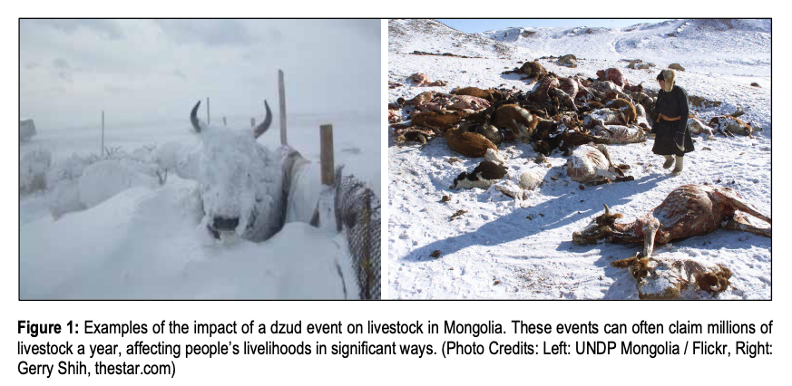
2. Understanding and Predicting Dzud Events and Their Impacts in Middle and High Latitude Drylands
Led by Professor Kyle McDonald (Earth and Atmospheric Sciences)
Objective:
Students will characterize dzud event risk and severity, assessing relationships between remote sensing datasets (e.g. soil moisture and land freeze/thaw state), dzud events, and associated socioeconomic impacts. Based on this analysis, students will develop an assessment framework for use in risk mitigation strategies. The understanding gained supports integration of physical and social sciences into decision making for anticipatory action.
Background:
Drylands in the middle and high latitudes have harsh environments with characteristically cold and arid climates. The livelihoods of the people inhabiting these areas are threatened by constant climate-related natural hazards. Dzud is the Mongolian term for a natural disaster resulting from harsh winter conditions that reduce availability or accessibility of pastures, leading to an extensive loss of livestock/wildlife from either starvation or cold during the winter-spring. These events occur in grasslands and tundra in significant portions of the mid to high latitudes, covering approximately 45% of Earth’s terrestrial area. In Central Asia, these events have significant humanitarian impacts because they affect local livestock populations, especially in Mongolia where approximately 30% of the workforce is dependent on herding for a substantial part of their livelihoods. In North America, these events are called winter kill, and they can result in massive die-offs of wildlife.
The current dzud early warning system in Mongolia has been in place since 2015 and is developed by the Information and Research Institute of Meteorology, Hydrology and Environment (Mongolia) in collaboration with Nagoya University in Japan. However, fully characterizing summer and winter conditions associated with dzud risk has been a challenge, and false positives associated with prediction of dzud events are high.
This capstone study seeks to employ state-of-the-art remote sensing datasets collected from Earth orbit to develop risk and severity assessments for dzud events and associated socioeconomic impacts to inhabitants of dzud-prone regions. Initial emphasis will be on the dryland steppe of Mongolia where records of dzud events are available. Extension to other parts of the terrestrial high latitudes will include analysis of die-off events in North America.
Suggested Approaches:
(i) Investigate the relationship between dzud event occurrence, non-frozen season soil moisture (SM) conditions, and winter/autumn/spring freeze/thaw (FT) state conditions using remote sensing datasets, ground-based station data, and dzud occurrence data. NASA’s Soil Moisture Active-Passive (SMAP) mission provides SM and land surface FT state datasets beginning in 2015. Explore the role of FT timing and past summer SM for different vegetation zones in Mongolia.
(ii) Building on results from (i), produce remote sensing-informed dzud risk maps based on prior summer soil moisture, current freeze/thaw state conditions, and ancillary datasets through an analysis conducted in a GIS framework supporting multi-criteria decision analysis.
(iii) Extend results to the regions of the global middle and high latitudes. (iv) Conduct risk and socioeconomic impact assessments.
Students should be comfortable working with computer analysis tools and a GIS analysis framework.
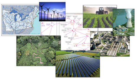
3. Impacts of Climate Extremes on the Food-Energy-Water Nexus, Engineered Systems and Nature-based Infrastructure: Use of Simplified Models
Led by Charles J. Vörösmarty, Ph.D., Environmental Sciences Director of the ASRC
Objective: To actively support and participate in a stakeholder engagement effort with a National Science Foundation-funded team of researchers exploring risks to food, energy, and water systems (FEWS) under future climate change. The specific objective is to evaluate response options to extreme weather using engineered and natural infrastructure. Students will learn how to set-up and run simple computer models, enabling them to execute and then present a systematic assessment of future management options to cope with climate extremes from the present-day through 2080. These results will be presented in professional workshops involving regional planners, policymakers, and managers.
Background: In recent years, growing evidence suggests that human-induced global warming is increasing the frequency and intensity of extreme weather events such as heatwaves, floods, intense precipitation, and drought. At the same time, the nation’s FEWS are supported by both traditionally engineered and natural infrastructure that yield economic benefits yet do not operate in isolation of each other or Earth system dynamics. Shifting patterns of drought and other severe weather in the U.S. have already lowered crop yields, raised food prices, with economic impacts extending well beyond the U.S. to countries importing our goods. In the electric power sector, changes in seasonal water shortage and elevated river temperatures are tandem concerns, reducing generation efficiencies, and constraining power generation during periods of peak demand. Complicating such tradeoffs are environmental regulations, like the Clean Water Act, with its thermal effluent limits designed well before climate concerns entered the policy domain. Carbon mitigation and climate adaptation policies also need to be considered. Understanding how climate-related shocks move through the FEWS is a major national imperative that will greatly impact the management of traditionally engineered (e.g., dams, irrigation, water treatment plants), natural infrastructure (e.g., land, aquatic systems), and their combination. This project focuses on two strategically important regions of the U.S., the Northeast (NE) and Midwest (MW), where FEWS are essential to the nation’s prosperity and to international food security. Major decisions affecting global food production, biofuels, energy security and pollution abatement will require innovative planning, which itself requires foundational scientific study, which this project seeks to provide.
Suggested Approaches:
1. Study the conceptual underpinnings of FEWS in the NE and MW through a literature-based review. From this, create an information resource on how engineered and nature-based infrastructure can be used to better manage food-energy-water systems at the regional scale.
2. Participate in NSF team meetings to gain insight into the studies of the research group, particularly how scenarios are being designed.
3. Interact with NSF team members to organize and carry out the science-to-policy dialogue with outside stakeholders.
4. Learn a reduced complexity modeling approach in order to set-up and run existing models of the regional FEWS. Assemble appropriate data sets to “drive” these models as well as to validate them (against observed statistics and data). Express outputs in easy-to-understand, intuitive forms, using suitable graphics and other descriptors.
5. Canvass stakeholder concerns and use these to construct scenario storylines, to which the simplified models will be configured and run into the future.
6. Create a synthesis of results (summaries and interpretation) that will help the information users understand the implications of the future scenario results.
4. Advancing Transportation Resiliency through Life Cycle Cost Assessment
Led by representatives from the NYC Department of Transportation and NYC Mayor’s Office of Resiliency with Katherine Silverman
OBJECTIVE
New York City Department of Transportation (DOT) in partnership with NYC Mayor’s Office of Resiliency (MOR) is defining climate resiliency for transportation. A key component of this work is incorporating forward-looking climate data into capital planning and projects. This initiative is related to defined goals in A Stronger, More Resilient New York, OneNYC, as well as UN Sustainable Development Goal 12: Climate Action. DOT’s in-house resiliency team has established vulnerability of assets to various climate hazards and is beginning to implement mitigation strategies across capital projects. As implementation progresses, common typologies of resilient design interventions are emerging. DOT is interested in establishing business as usual practice for resiliency informed by life cycle cost analysis for both discrete project level decision making as well as long term planning. The ideal team would create a tool to be used by DOT to provide costs associated with transportation resilience design interventions, as well as risk avoided, with flexibility for this tool to be utilized by other infrastructure agencies. The end product of this work will advance agency-wide conversations on resiliency standard of practice.
BACKGROUND
The field of transportation climate resiliency is rapidly evolving, with NYC setting standards of practice in the United States. The New York City Panel on Climate Change (NPCC) provides localized datasets for projected changes to temperature, precipitation, and sea level rise/storm surge. Using these datasets, NYC MOR in partnership with city agencies created the NYC Climate Resiliency Design Guidelines that provide design standards for incorporating forward-looking climate data into capital projects. DOT has made significant progress in incorporating the Guidelines into capital planning. Through application of the Guidelines on common DOT capital projects, typologies of common design interventions are forming (ex. Increasing planted areas, permeable pavements, filter strips, street raising). In order to continue to advance resilient design strategies, cost information specific to the typologies DOT utilizes most frequently is essential.
Life cycle cost assessment takes a holistic view of an investment, thereby giving a full picture of cost considerations from design to operation. DOT is particularly interested in exploring both capital (first costs) and operational (long term costs) over the entire useful life of the investment. Once obtained, a tool for use by planners and designers will integrate this information into existing procedure. This process can be used to inform capital planning with the ultimate goal of incorporating resilience design standards into DOT standard of practice.
SUGGESTED APPROACHES
- Data collection: In partnership with NYC DOT and MOR, identify common resilient design features used to mitigate climate risk (for example – heat mitigation efforts such as street tree planting, sea level rise mitigation such as raising road elevation). Through literature review, outreach to transportation entities across the US, and using DOT available cost information, establish parameters for the LCCA.
- Analysis: Perform LCCA assessment of resilient design features. This is a high level exercise.
- Output: Create a tool for planners and designers to utilize in early project scoping for informed decision making on resilient design features.
IDEAL TEAM
The ideal team would be comprised of team members of mixed backgrounds: someone with architecture or civil engineering background; someone with social science training (e.g., high marks in economics); someone with a planning and policy background—in particular with experience reaching out to city officials (most ideal: experience with transportation entities).
5. Resilient. Renewable. Rikers.
Led by Katherine Gloede Silverman and Drew Silverman, Director of Energy Assessment at Aypa Power
OBJECTIVE
New York City Mayor Bill De Blasio recently signed a bill that will permanently close the jail on Rikers Island, slowly transfer jurisdiction to the City’s Department of Citywide Administrative Services (DCAS), and commission a study on the viability of renewable energy and battery storage on the Island. The objective of this capstone project is to reimagine Rikers Island by examining the Mayor’s proposed uses, evaluating additional sustainable interventions, and assessing the climate and social resiliency of future uses through an environmental justice lens.
BACKGROUND
New York City is both on the forefront of many climate change adaptation strategies and climate vulnerability as a coastal city. As such, much work has been done to ensure the City is prepared for events such as the next Sandy, increasing days of extreme heat, and gradual Sea Level Rise. Though this is true in many neighborhoods around New York City, little has been done to study neither on-site renewable energy storage nor sustainable opportunities for Rikers Island. All this at a time when the City seeks to close Rikers Jail, move inmates to local jails within the Five Boroughs, and slowly reimagine how the Island should be used in the future. With a bill signed to move forward with closure and study options for renewable energy implementation and battery storage, the next few years are the perfect moment to propose options as experts and city officials will soon seek the ideal plan.
Systemic racism and economic injustice has led to many inmates being wrongfully held at Rikers. In turn, the Jail has historically adversely impacted lower income and largely minority communities around the City. It is therefore critical that interventions for Rikers include targeted retribution for these families and communities–especially as New York plans to legalize marijuana in the next year. This environmental justice approach is less likely to be adopted by City Officials and thereby a meaningful topic for a graduate student research.
SUGGESTED APPROACHES
- Site Assessment: A full topographic analysis of the Island including existing infrastructure and built environment, soil and water, and future concerns.
- Energy Modeling: An optimized energy model for the maximum capacity combination of power generated and stored on the island, taking into account any climate stressors and other meaningful uses. Eg. Should there only be turbines or a mixture with solar panels? Is large-scale battery storage viable? Who should the power go to and how?
- Resiliency Plan: Examination of other ideas for the Island that will elevate social and environmental resilience for both the Island itself and communities Citywide.
- Design Proposal: A full mock up of various ideas for the Island that take into consideration best uses, best practices, resiliency, and benefits to communities historically negatively impacted by the Jail.
IDEAL TEAM
This project needs at least one engineer who has completed the elective in Renewable Energy and one person confident in AutoCAD to complete renderings. Otherwise, an interest in either renewable energy or environmental justice is great!
6. Sustainability in the Urban Environment: Environmental Impacts of Electric Vehicles
Led by Professor Robert Paaswell (Civil Engineering)
Objective: The current planning of this Administration is to phase out all motor vehicles operated with carbon-based fuel and replace with Electric Vehicles (EVs). To that end pending federal legislation proposes to blanket the US with charging stations; meanwhile vehicle manufacturers are designing vehicles that can be charged at home. Are the current plans beneficial, harmful or neutral to the environment?
Background: The growth of motor vehicle use (in VMT, trips/person, MV/HH, etc.) since 1916 have been well documented. Since 1921 the Federal Government has subsidized road growth and the importance of State DOTs. In 1956 this support took a huge boost with the introduction of the Interstate Highway Program and the permanence of the Highway Trust fund. One of the results of motorization of the US was a dramatic shift in populations. In 1916, the US was primarily rural, with a large per cent of the population living in urban areas. The “highway programs” and the rapid growth of HH Car Ownership has led to a dispersion of population. Today, more people live in urban areas than in rural areas; the majority of people living in urban areas live in suburban (lower density) areas. This has led to unremitting congestion, extensive travel times and declining air quality. Is anything gained by trading a carbon fuel powered vehicle for an electric vehicle?
Methods:
- Define the problem to be studied and develop the study objectives
- Examine ways to meet the objectives
- Literature search
- Consultation and lectures by experts
- Review of methods of analysis
- Review of Benefit-Cost Analysis (BCA)
- Apply chosen methodology of analysis
- Develop criteria for accepting conclusions
- Develop impact statements for conclusions:
- Impact on population distributions
- Impact on mode choice and use
- Impact on the environment
- Economic impacts
- Develop proposed next steps, based on conclusions
Note: The transportation and planning literature is filled with studies of the impact of the highway program, methods of analysis and the results of BCA and impact studies. This project is asking the study team to use what is given as a starting point and forecast the future impact of a “new” mode – EVs, their acceptance and use. The problem is real, critical and of great importance.
7. FENCE-LINE COMMUNITIES: Impacts on the Human Population and Ecosystem
Led by Professor Susan Kaplan (Architecture)
OBJECTIVE
Through research and analysis, the students will choose a specific fence-line community in the New York Metropolitan area to focus upon. Then they will connect with local community advocates and health officials to report on the negative impacts on the human population and ecosystem of the community. They will search for the direct causes of the local issues.
Working with community organizations the students will attempt to find actions that could be taken to support existing advocacy and further improve community conditions
BACKGROUND
Fence-line communities are defined as neighborhoods directly adjacent to factories, power plants, or other polluting infrastructures. There are several fence-line communities in New York City, and significant ones in nearby New Jersey.
Extreme health, safety and economic impacts face these areas. The areas are often referred to as “sacrifice zones”.
The vulnerability of fence-line communities raises questions of environmental justice and equity. In an era of climate change and unpredictability, these concerns are amplified. Increased damages due to flooding and/or excessive heat are particularly harmful to fence-line communities. Habitat disruption contributes to all these impacts.
Pollution and other chemical dangers both, long and short term, affect these communities. Schools, hospitals, and residences are exposed to these dangers daily. The pandemic has also exposed many of the vulnerabilities that populations living in these communities’ continually face.
Powerful manufacturers, lobbyists, and faulty government policies allow these problems to continue.
Much has been written and researched relating to impacts of living in fence-line communities nationwide. There exists vibrant advocacy on this topic.
Not only is change needed to promote a better future and resiliency, but the very existence of these communities is at stake.
Background Research.
- Gain a clear understanding of dangers and issues facing fence line communities nation-wide.
- Explore existing advocacy related to fence-line communities
- Map out local fence-line communities and find a local fence-line community that has established community support groups which are willing to work with students and can use the types of help that the students could provide.
SUGGESTED APPROACHES: FOCUS ON SPECIFIC COMMUNITY
Through research and working with local community groups and health officials explore the following:
- History of area and what factors allowed it to become a “Sacrifice Zone”.
- The economic, social, and cultural aspects of the community and general demographics of the location.
- The existing health problems and safety dangers.
- Causes of specific existing conditions that create dangers, ecological damage, and health problems.
- Effects from factories, power plants, or other polluting infrastructures, and local governmental policies.)
- The role of habitat disruption, waste mismanagement, andwater pollution.
- Existing advocacy and improvement plans
Wherever data is missing, ask community permission to do original research to fill in gaps of existing data bases and perhaps create new databases.
REPORT AND RECOMMENDATIONS
- Develop a report outlining research and other exploratory initiatives.
- Make connections between the specific local problems and the larger issues of climate change, resiliency, habitat disruption, air, land, and water pollution, waste management, political policies, and social equity
- In conjunction with community organizations determine what actions can be taken to both support and expand existing action and advocacy plans.
8. Source separation of residential food waste and its impact on landfilling operations
Prepared by: Vasil Diyamandoglu, Environmental Engineering
Project Description: City government structures are typically responsible for the collection, recycling, reuse and ultimately disposal of the trash generated by residents. Current local laws and ordinances require source separation (in residences) of the solid waste generated, followed by recycling of paper and cardboard, GPM (glass, plastic, and metal), and terminal disposal of the remaining trash to landfills.
Source Separation of Food Waste: In recent years attention has been directed in the value of food waste (mostly fresh produce, fruits etc) as source for organic carbon and nutrients that may also be source separated from the solid waste stream, and either be composted aerobically, or subjected to anaerobic digestion in conjunction with sludges from biological wastewater treatment plants. Extensive anaerobic digester capacity is available in most of the New York City Wastewater Treatment Plants. Since it has been documented that in New York City, food waste constitutes up to 25% of the solid waste stream by weight, the removal of it from trash will cause a very substantial change in its properties and physical, chemical and biological characteristics of the trash being disposed of in Landfills.
Principles of Landfill Operations: Landfills are designed to receive daily deliveries of extensive volumes of solid wastes that currently include organic wastes. The objective is to provide the right conditions for anaerobic degradation of the organics to occur, thus producing CO2 and CH4 which is added to the methane generation, which are collected from the air tight operation. The moisture within the trash, mostly due to the vegetable and fruit content of the trash, leaches out and produces the liquid waste stream typically called leachate. Finally, the structural integrity of the closed landfill changes over time as the decomposition of the food waste in the landfill continues to convert to greenhouse gasses.
Capstone Project Problem: The fate of the organic fraction of the solid waste deposited in landfills depends highly on the condition of the anaerobic digestion process. Removal of the food waste from landfills will make irreversible changes in the long term behavior of the materials deposited in the landfill during the lifetime which consist of the period it received refuse and well as after its closure. In the absence of the biodegradable organic waste will render the cells in a landfill more stable, the leachate formation would be a lot smaller and the post closure structural stability of the cover as well as the uses of the land above a landfill would be reassessed.
Research Methodology: Since diversion of food waste is a recent idea still under development, it will be impossible to find operating landfills under “food waste free” conditions. The focus of study will remain within the composition and behavior of the food waste free “trash” stream. The members of the capstone group will implement an experimental study where they each will carry out residence based source separation, and they will quantify the fraction of household waste that remain as “food waste free” trash. The seasonal nature of the trends will be ascertained. The results will be used to develop a comparative design of the same landfill with and without food waste in the disposal stream.
9. Policies to Address Equitable Access to Clean Energy Careers
Led by Solar One and Katherine Gloede Silverman
Objective: Identify policies, strategies, or programs that ensure access to growing clean energy careers is equitable. Look for examples of research driven best practices that could be replicated and shared. Background
Clean energy will help protect the environment for future generations while creating good, local jobs and more sustainable and resilient communities. As one of the fastest growing sectors in the nation, the solar industry has the potential to transform the energy grid to clean power, provide critical jobs that will steward the post-COVID economic recovery, and help rectify a troubling history of environmental injustice. As the US moves to invest in clean energy and energy efficiency it is critical to build equitable access to growing clean energy jobs. According to the National Solar Jobs Census published by the nonprofit advocate, The Solar Foundation, the solar workforce is 73% white and 74% male. This suggests that communities of color bearing the brunt of environmental degradation are not accessing jobs in the sector. Suggested Approaches (i) Start research locally within New York City and New York State. Consider looking at policies and programs funded via NYSERDA (The New York State Energy Research and Development Authority) (ii) Identify policies in other states and cities that advance equitable clean energy job growth. How long have these policies been in place? What research has been done to demonstrate effectiveness? Identify policies and programs related to equitable workforce development in other sectors. How can these be replicated or revised specifically for clean energy careers?(iii) Report back on existing policies and make recommendations for how they could be replicated or scaled up nationally.
10. Water Risk for the Bulk Power System
Led by Dr. Charles Vorosmarty, Engineering
Students already on board: Hussain Bokhari
The main objective of the overall project is to assess water related constraints to electricity generation in the conterminous United States (CONUS), an ongoing research collaboration between CUNY, National Renewable Energy Laboratory, Oakridge National Laboratory, and Sandia National Laboratory. A diverse socio-environmental modeling effort seeks to study the efficiencies and hydrologic and economic impacts of water and energy infrastructure, namely thermal power plants, hydropower plants, and reservoirs and dams, with natural and anthropogenic stressors. Much of the technical work is in developing and upgrading geospatial datasets, features, and linked dynamics of multiple comprehensive models, including Water Balance Model (WBM), Thermoelectric Power and Thermal Pollution Model (TP2M), Reservoir Operation Module (RO), and Regional Energy Deployment System (ReEDS).
How the Capstone project fits into the ongoing work is more open ended and will be developed through discussions based on the collective interests and qualifications of the SUS students. An important aspect of the research project is scenario experimentation, from future climate scenarios and extremes to a host of policy and infrastructure scenarios, designed to explore the vulnerabilities of and management solutions for freshwater supplies, shared waterways, and power demands. The substantial national databases and model interactions available, therefore, can open many potential avenues for a student-led project to investigate and develop proposals for energy-water systems, emphasizing on infrastructure and policy.
To form a balanced and collaborative team, individual expertise in any of the following areas will help to formulate insightful and dynamic environmental, engineering, and economic analyses. Experience with GIS as well as programming languages (e.g. Python, R) is strongly preferred for the extensive data analytics and programming involved. Experience with data visualization and technical writing is vital to communicating dense and complex information.
11. Analysis of Federal Disaster Recovery Funding Allocations and the TRADE-OFFS BETWEEN REBUILDING, BUYOUTS, and LAND ACQUISITION
Prof. James Biles (Geography)
Students already on board: Colin Cotter
Objective
This proposed capstone project has three objectives. Participants will assess federal disaster recovery spending on rebuilding, buyouts and land acquisition for three of the most severe storms of the past two decades. In addition, the project will investigate whether allocation of federal resources for buyout, land acquisition and rebuilding comply with official decision-making criteria and guidelines, especially in light of the high costs and added risks of climate change and sea level rise. Furthermore, the study will determine if increasing investment in mitigation strategies is a more cost effective and sustainable strategy for post disaster funding and planning.
Background
Federal disaster recovery funding, which is channeled through state and local governments, is primarily allocated for home repairs (rebuilding). Only a small percentage of funding goes towards mitigation and resiliency efforts, such as buyouts of high-risk properties and land acquisition. This project will compare federal disaster recovery spending allocations for Hurricanes Katrina and Harvey, as well as Superstorm Sandy, to assess trends in spending for rebuilding versus mitigation efforts. In addition, state and city-level geographic data for government funded repairs/rebuilds, land buyouts, and acquisitions will be analyzed to identify the number of properties and residents that have successfully been relocated from flood-prone areas and how many homes have been repaired and/or rebuilt. This analysis will reveal whether there is a clear and consistent logic to rebuilding, buyout and property acquisition decisions in the aftermath of natural disasters. The relationship between the location of rebuilds, buyouts and acquisitions and relevant demographic information for selected neighborhoods and/or municipalities will also be analyzed to identify any possible bias in how rebuilding, buyouts, and land acquisition decisions are implemented.
Suggested Approach
1) Gain practical understanding of US federal disaster recovery programs, including funding trends, decision-making criteria, and patterns of resource allocation.
2) Identify the social, economic and environmental impacts of Hurricane Katrina, Hurricane Harvey, and Superstorm Sandy.
3) Collect and analyze relevant demographic data for New Orleans, Houston and New York City metropolitan areas.
4) Analyze allocation of federal disaster recovery spending for Hurricane Katrina, Hurricane Harvey, and Superstorm Sandy.
5) Evaluate patterns of disaster recovery spending for rebuilding, buyouts and land acquisition with federal decision-making criteria.
6) Become familiar with climate change scenarios for New Orleans, Houston and New York City metropolitan areas.
7) Assess patterns of federal disaster recovery spending following Hurricane Katrina, Hurricane Harvey, and Superstorm Sandy in light of relevant climate change scenarios.
12. Re-discovering developing communities in the Bogotá area through an interdisciplinary study of landscape, ecology and hydrology
Led by Zihao Zhang (Architecture)
Student group: Paula, Alejandra, Luisa
ABSTRACT
Throughout recent decades, the city of Bogotá, Colombia has experienced a phenomenon of accelerated expansion in its peripheral settlements that surround the urban center, encroaching on the natural spaces that surround the city. These urban settlements have lacked any urban planning and have developed based on the needs of the inhabitants. Consequently, these regions of the city represent areas of high environmental, social, and economic impact. These factors have made Bogota a highly interesting place for studying and designing interventions focused on landscape, urban infrastructures, and concepts of social and sustainable development.
PROPOSAL INTERVENTION The project focuses its development in the Usme locality. Usme is one of the peripheral neighborhoods that has undergone the aforementioned expansion. Located southeast of Bogota, with a population of approximately 748,012 inhabitants, has an area of 21,506 hectares, of which 2,120 correspond to urban land, 902 ha are classified as urban expansion land, and the remaining 18,483 ha are rural land. It is important to highlight that the land classification has been modified according to the expansion of informal settlements within the Usme locality, of which its population belongs to socioeconomic strata 1 and 2, which are the lowest in the city. In addition, the town is part of the area of the upper basin of the Tunjuelo River, cataloged as the largest in the city with 73 kilometers in length. These features make the town of Usme a potential area for the development of an urban intervention proposal that mitigates the effects of the uncontrolled expansion of informal settlements, encompassing environmental, social, and landscape concepts within the framework of sustainable development. This capstone aims to integrate urban planning, landscape, and infrastructures, to promote the development of the neighborhood, acting according to the principles of sustainability. Furthermore, the objective of this proposal is to serve as a model for future interventions in peripheral areas of Bogotá with the same characteristics.
13. Living Walls in the New York City Subway, a Natural Pollutant Removal System
Led by Professor Professor Beth Wittig, Engineering
Student already on board: Adam Tarakhan
Objective
- Evaluate living walls as a feasible option for absorbing fine particles, filtering air, and adding oxygen to the New York City subway system.
- Create the best design for a permanent living wall structure for a large New York City subway transfer station.
- Create a design to be aesthetically pleasing, that employees can enjoy working alongside of, and commuters can enjoy viewing while waiting for a train or when walking through a tunnel at a transfer station.
- Discover additional benefits of living walls for the system, such as heat absorbing qualities for hot stations, and water collection during heavy rainstorms.
- Positively Impact riders’ and workers’ mental health.
- Pinpoint which station would be best for these installations.
- Create the best lighting schedule with the proper lighting array with growing bulbs.
- Examine and determine which lights should be switched with growing bulbs.
- Design a watering schedule and maintenance regime for the plants.
Background
New York city subway station air levels are contaminated with high levels of PM 2.5 and CO2. The worst offenders are large transfer stations which have the highest concentrations levels of PM 2.5. Not only is the air quality poor, but the temperatures can also be uncomfortable. Subway stations can have temperatures that exceed 100 degrees in the summer. Historically, stations lack any type of greenery; this leaves the stations bleak and depressing. Subway stations can also be damp and smelly. It is known that added greenery enhances people’s moods. In many stations, the levels of PM2.5 far exceed the Environmental Protection Agency’s safety standards. PM2.5 levels are comparable to sooty contamination from forest fires and building demolition. Subway systems already have an established lighting system that is on 24 hours, seven days a week. Could part of this system be utilized for lighting plants?
Suggested approach
I propose filling a subway station with living walls to act as a natural filtration system. The living walls will be up to 10 – 20 feet in length, filled with thousands of plants that will add fresh oxygen, absorb PM 2.5, and filter CO2. A whole platform could be filled with these 10-20’ segments of living walls. They will be evenly placed and have a design that is aesthetically pleasing. The living wall will consist of plants that need low light, low levels of water, and have high filtration properties. For example, ivies are very good at filtering air and don’t need much light or water, but this plant may not be the best for absorbing PM 2.5 — so further investigation will need to take place. Live measurements will be taken at the subway station before and after installation to monitor impacts on PM2.5 and oxygen levels over time. Renders and site plans will be created to fully demonstrate the design structure, engineering and implantation.
Further Research questions
A huge part of the experiment will see what effect plants have on PM 2.5 in an underground environment. It’s known some plants are more effective than others at filtering PM 2.5 and collecting dust, and some have very little effect at all. It will be important to discover which species will be the best at combating and absorbing these heavy particles. Controlled experiments might be needed if the appropriate research is not available. Can an increase in oxygen in itself be a good way of decreasing the impact of PM2.5 by providing fresh oxygen in the immediate area? What level of filtration do Living Walls have when you consider size and location? What is the quality-of-life improvements as well? Will the air feel fresher in a station that is filled with living walls? Are MTA employees and commuters more positive?
Ideal Team
My Ideal team will consist of people with backgrounds and knowledge in: architecture, landscape architecture, botany, and engineering. An architect who is familiar with the design and implementation of façade-like structures. Landscape architect who is familiar with propagation, soil quality, lighting conditions for growing plants, plant identification and living walls. A mechanical or civil engineer with knowledge about ventilation, filtration systems and energy modeling software. Any background knowledge on air quality, ventilation and filtration will be welcomed. In addition, knowledge in horticulture, botany, biology of plants, and plant identification will also be an asset.
Conclusion:
The subway stations have miles of empty walls that could be filled with living walls, which is currently unused space. We’ve created additional habitats underground, but they are lacking so much of what makes a healthy system. Plants are the quintessential entity for a healthy, functioning environment. If living walls can be successfully grown underground, we can potentially have acres and acres of added green space to New York City that was otherwise never there. Living walls will clean the air, enhance the mood, health, and visual appeal of an environment we use on a daily basis.
14.
Led by the Building Performance Lab
Student already on board: Po Ki Chui
Objective
Identify and develop a minimum viable set of open data and policies for cities to reduce carbon emissions in buildings. The solution serves as a turn-key solution for cities that have not been heavily investing in climate change policies.
Background
Understanding the data has become an important integral component for the policy making for cities and organizations. Buildings account for nearly 40% of global carbon emissions. New York City and some other US cities have adopted an open data platform coupling with local laws mandating building owners to reduce carbon footprint from their buildings. While NYC is unique in its population density and building compositions, can other cities learn from these pioneer cities and start a minimum viable solution to combat climate change? The learnings and effectiveness of data transparency and local laws should be analyzed and replicated to other cities. This project aims to discover and develop a minimum set of local laws, open data and tools for future cities to have a turn-key solution when they are ready to combat climate change.
Suggested Approaches
Research analysis: Identify common key attributes between cities that have developed the open data and local law framework and the ones have not. Attributes can include distribution of building types in the city, energy-related system types in buildings, building or population density, commercial versus residential buildings, etc.
Problem scoping: Once the common key attributes are identified, define the scope of the problem that can be achieved within the Capstone project timeline (i.e. < 1 year). The idea is to develop a framework to re-apply the policies and data from pioneer cities to those that are behind.
Local Law development: Developing a minimum viable set of local laws for carbon reduction for the key common city attributes, likely learning from the cities that have established local laws for climate change.
Open data MVP modeling: Identifying and developing a minimum viable set of open data and tools to monitor trends for the progress of the local laws.

This entry is licensed under a Creative Commons Attribution-NonCommercial-ShareAlike 4.0 International license.